 IDECyL
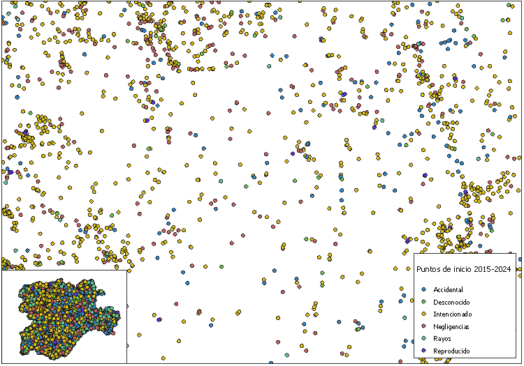
Incendios CyL: Plan 2026. Puntos inicio 2015-2024
Mapa de frecuencia de incedios forestales durante el período 2015-2024
Representación cartográfica de los puntos de inicio de incendios forestales en la Comunidad Autónoma de Castilla y León del Plan Anual de Prevención, Vigilancia y Extinción de Incendios Forestales 2026.
* Aviso: VERSIÓN ANUAL DE DATOS CARTOGRÁFICOS
Simple
- Fecha ( Fecha de creación )
- 2026-02-09
- Fecha ( Fecha de revisión )
- 2026-02-12
- Identificador
- https://idecyl.jcyl.es / plainc26_cyl_puntos_inicio_2015_2024
- Horario de atención
- Laborables de 09:00 a 14:00
- Formato de presentación
- Mapa digital
- Propósito
- Difusión de información geográfica de Castilla y León
- Créditos
- Junta de Castilla y León (JCyL)
- Créditos
- Instituto Geográfico Nacional (IGN)
- Créditos
- Ministerio para la transición ecólogica y el reto demográfico (MITECO)
- Frecuencia de mantenimiento y actualización
- No planificado
- GEMET - INSPIRE themes, version 1.0 ( Tema )
- Categorías IDECyL ( Tema )
-
- Medio Ambiente
- Uso específico
- Consultas sobre riesgo de incendios de Castilla y León con opciones de superposición e interoperabilidad.
- Limitaciones de acceso
- Otras restricciones
- Otras restricciones
- Sin limitaciones al acceso público.
- Limitaciones de uso
- https://datosabiertos.jcyl.es/web/jcyl/RISP/es/Plantilla100/1284235967637/_/_/_
- Limitaciones de acceso
- Otras restricciones
- Restricciones de acceso y uso
- Licencia
- Otras restricciones
- Sin validez jurídica, carácter informativo. Uso libre y gratuito. Cita obligada a la propiedad de la fuente: "Junta de Castilla y León". Condiciones detalladas en:
- Tipo de representación espacial
- Vector
- Factor de escala
- 10000
- Idioma del metadato
- Spanish; Castilianes
- Codificación de caracteres
- UTF8
- Categoría temática
-
- Cobertura de la Tierra con mapas básicos e imágenes
- Descripción
- EPSG:4326
))
- Identificador del Sistema de Referencia
- http://www.opengis.net/def/crs/EPSG/0/25830
- Formato de distribución
-
-
vnd.shp
(
Desconocido
)
- Técnica de descompresión de archivos
- shapefile comprimido en zip
-
geopackage+sqlite3
(
Desconocido
)
- Técnica de descompresión de archivos
- geopackage comprimido en zip
-
gml+xml
(
Desconocido
)
-
vnd.shp
(
Desconocido
)
Distribuidor
- Importes
- Descarga gratuita a través de la IDECyL
- Unidades de distribución
- link_info
- Recurso en línea
- ORDEN MAV/92/2026, de 9 de febrero, por la que se aprueba el Plan Anual de Prevención, Vigilancia y Extinción de Incendios Forestales para el año 2026. ( WWW:LINK-1.0-http--link )
- Unidades de distribución
- visualizacion
- Recurso en línea
- VER MAPA ( WWW:LINK-1.0-http--link )
- Unidades de distribución
- descarga_xlsx
- Recurso en línea
- Listado Excel (*.xlsx) ( WWW:DOWNLOAD-1.0-http--download )
- Unidades de distribución
- descarga_gpkg
- Recurso en línea
- Fichero Geopackage (*.gpkg) ( WWW:DOWNLOAD-1.0-http--download )
- Unidades de distribución
- descarga_shp
- Recurso en línea
- Fichero Shapefile (*.shp) ( WWW:DOWNLOAD-1.0-http--download )
- Unidades de distribución
- descarga_shp_prov
- Recurso en línea
- Ficheros PROVINCIALES ( WWW:DOWNLOAD-1.0-http--download )
- Unidades de distribución
- link_wms
- Recurso en línea
- plainc26_cyl_puntos_inicio_2015_2024 ( OGC:WMS )
- Nivel jerárquico
- Conjunto de datos
- Conjunto de datos
- incendios:plainc26_cyl_puntos_inicio_2015_2024
Resultado de conformidad
- Fecha ( Fecha de publicación )
- 2008-12-04
- Explicación
- Consultar el reglamento mencionado
- Aprobado
Resultado de conformidad
- Fecha ( Fecha de publicación )
- 2010-12-08
- Explicación
- Consultar el reglamento mencionado
- Aprobado
Resultado de conformidad
- Fecha ( Fecha de publicación )
- 2010-12-08
- Explicación
- See mentioned regulation
- Aprobado
- Declaración
- Cartografía de peligro de propagación de incendios forestales (propagación/frecuencia) y cartografía de peligro de consolidación (consolidación/frecuencia incendios > 50ha) de JCyL
- Descripción
- Superposición de fuentes para determinación y tipificación de áreas de peligro de incendios forestales
- Descripción
- Integración y fusión de capas
- Descripción
- Tratamiento alfanumérico
- Descripción
- Correccíón geométrica y depuración topológica
- Descripción
- Control y validación
- Descripción
- Cartografía de peligro de propagación de incendios forestales
- Factor de escala
- 10000
- Identificador del Sistema de Referencia
- EPSG:25830
- Descripción
- Cartografía de peligro de consolidación de incendios forestales
- Factor de escala
- 10000
- Identificador del Sistema de Referencia
- EPSG:25830
- Descripción
- Estadística de incendios forestales
- Descripción
- Modelo digital del terreno PNOA 25m
- Factor de escala
- 25000
- Identificador del Sistema de Referencia
- EPSG:25830
- Descripción
- Mapa forestal de España (MFE25)
- Factor de escala
- 25000
- Identificador del Sistema de Referencia
- EPSG:25830
- Descripción del
- fid:identificador numérico único
- Tipo de contenido
- Clasificación temática
- Descripción del
- c_n_egif:código identificador de parte de incendio
- Tipo de contenido
- Clasificación temática
- Descripción del
- x_25830:cooordenada X ETRS89UTM30N de referencia
- Tipo de contenido
- Clasificación temática
- Descripción del
- y_25830:cooordenada Y ETRS89UTM30N de referencia
- Tipo de contenido
- Clasificación temática
- Descripción del
- n_mun:nombre de término municipal
- Tipo de contenido
- Clasificación temática
- Descripción del
- n_comar_ma:nombre de comarca de medio ambiente
- Tipo de contenido
- Clasificación temática
- Descripción del
- n_prov:nombre de provincia
- Tipo de contenido
- Clasificación temática
- Descripción del
- n_auton:nombre de autonomía
- Tipo de contenido
- Clasificación temática
- Descripción del
- c_prov_mun:código de identificación de pertenencia a provincia y término municipal o terreno comunal o jurisdiccional (5 dígitos) asignado por la Junta de Castilla y León (JCyL)
- Tipo de contenido
- Clasificación temática
- Descripción del
- d_tippunto:tipo de causa origen de incendio
- Tipo de contenido
- Clasificación temática
- Descripción del
- c_emergenc:código de emergencia de incendio
- Tipo de contenido
- Clasificación temática
- Descripción del
- f_incendio:fecha de inicio de incendio
- Tipo de contenido
- Clasificación temática
gmd:MD_Metadata
- Identificador del archivo de metadatos
- spagobcyltemincp26punini XML
- Idioma del metadato
- Spanish; Castilianes
- Codificación de caracteres
- UTF8
- Nivel jerárquico (Tipo de recurso)
- Conjunto de datos
- Nombre del nivel jerárquico
- Conjunto de datos
- Fecha de creación
- 2026-02-09T00:00:00.000000Z
- Nombre de la norma de metadatos
- NEM:ISO 19115:2003 + Reglamento (CE) Nº 1205/2008 de Inspire
- Versión de la norma de metadatos
- TG 2.0
. Incendios CyL: Plan 2026. Puntos inicio 2015-2024.
https://idecyl.jcyl.es:443/geonetwork/srv/api/records/spagobcyltemincp26punini
Vistas previas
Proporcionado por
