 IDECyL
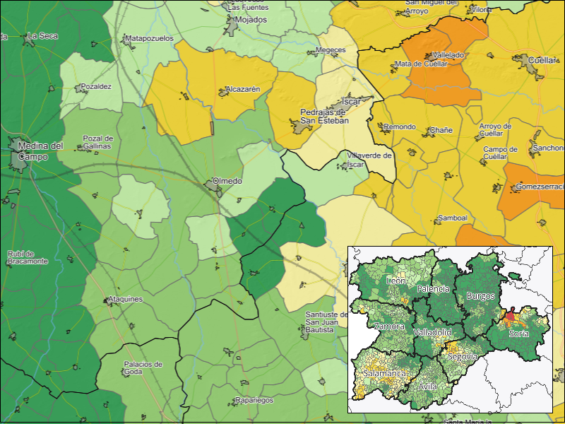
Contaminación agraria CyL: índice carga ganadera
Contaminación agraria difusa de Castilla y León: Índice de carga ganadera.
Mapa de estimación de nitrógeno de origen ganadero en Castilla y León.
Promedio del Factor Agroambiental Ganadero del término municipal y todos los inmediatamente colindantes. Expresado en Kg de N/ha SAU
A partir del factor agroambiental es posible evaluar la posibilidad de ampliación o implantación de nuevas explotaciones ganaderas por término municipal según ORDEN MAV/398/2022, de 29 de abril, de la Junta de Castilla y León.
Simple
- Fecha ( Fecha de creación )
- 2021-10-15
- Fecha ( Fecha de revisión )
- 2026-02-10
- Identificador
- https://idecyl.jcyl.es / coad_cyl_nitrog_ganad_municip_icg
- Horario de atención
- Laborables de 09:00 a 14:00
- Formato de presentación
- Mapa digital
- Propósito
- Difusión de información geográfica de Castilla y León
- Créditos
- Junta de Castilla y León (JCyL)
- Frecuencia de mantenimiento y actualización
- Según sea necesario
- GEMET - INSPIRE themes, version 1.0 ( Tema )
- Spatial scope
-
- Regional
- Categorías IDECyL ( Tema )
-
- Medioambiente
- Uso específico
- Consultas sobre contaminación agraria en Castilla y León con opciones de superposición e interoperabilidad.
- Limitaciones de acceso
- Otras restricciones
- Otras restricciones
- Sin limitaciones al acceso público.
- Limitaciones de uso
- https://datosabiertos.jcyl.es/web/jcyl/RISP/es/Plantilla100/1284235967637/_/_/_
- Limitaciones de acceso
- Otras restricciones
- Restricciones de acceso y uso
- Licencia
- Otras restricciones
- Sin validez jurídica, carácter informativo. Uso libre y gratuito. Cita obligada a la propiedad de la fuente: "Junta de Castilla y León". Condiciones detalladas en:
- Tipo de representación espacial
- Vector
- Factor de escala
- 25000
- Idioma del metadato
- Spanish; Castilianes
- Codificación de caracteres
- UTF8
- Categoría temática
-
- Cobertura de la Tierra con mapas básicos e imágenes
- Descripción
- EPSG:4326
))
- Identificador del Sistema de Referencia
- http://www.opengis.net/def/crs/EPSG/0/25830
- Formato de distribución
-
-
vnd.ms-excel
(
Desconocido
)
-
vnd.shp
(
Desconocido
)
- Técnica de descompresión de archivos
- shapefile comprimido en zip
-
geopackage+sqlite3
(
Desconocido
)
- Técnica de descompresión de archivos
- geopackage comprimido en zip
-
gml+xml
(
Desconocido
)
-
vnd.ms-excel
(
Desconocido
)
Distribuidor
- Importes
- Acceso gratuito
- Unidades de distribución
- Acceso a ORDEN MAV/398/2022, de 29 de abril, de la Junta de Castilla y León
- Recurso en línea
- ORDEN MAV/398/2022, de 29 de abril, por la que se aprueba el programa de actuación de las zonas vulnerables a la contaminación por nitratos. ( WWW:LINK-1.0-http--link )
- Unidades de distribución
- visualizacion
- Recurso en línea
- VER MAPA ( WWW:LINK-1.0-http--link )
- Unidades de distribución
- descarga_excel
- Recurso en línea
- Listado Excel (*.xlsx) ( WWW:DOWNLOAD-1.0-http--download )
- Unidades de distribución
- descarga_gpkg
- Recurso en línea
- Fichero Geopackage (*.gpkg) ( WWW:DOWNLOAD-1.0-http--download )
- Unidades de distribución
- descarga_shp
- Recurso en línea
- Fichero Shapefile (*.shp) ( WWW:DOWNLOAD-1.0-http--download )
- Unidades de distribución
- link_api_wms_dataset
- Recurso en línea
- coad_cyl_nitrog_ganad_municip_icg ( OGC:WMS )
- Nivel jerárquico
- Conjunto de datos
- Conjunto de datos
- sostenibilidad:coad_cyl_nitrog_ganad_municip_icg
Resultado de conformidad
- Fecha ( Fecha de publicación )
- 2008-12-04
- Explicación
- Consultar el reglamento mencionado
- Aprobado
Resultado de conformidad
- Fecha ( Fecha de publicación )
- 2010-12-08
- Explicación
- Consultar el reglamento mencionado
- Aprobado
Resultado de conformidad
- Fecha ( Fecha de publicación )
- 2010-12-08
- Explicación
- See mentioned regulation
- Aprobado
- Declaración
- Censo ganadero por termino municipal de la Consejeria de Agricultura y Ganadería de JCyL
- Descripción
- Integración de datos alfanuméricos y geométricos mediante unión de recintos de límites municipales de Castilla y León
- Descripción
- Cálculo de valor promedio entre municipios y términos colindantes mediante análisis espacial
- Descripción
- Base de datos del censo ganadero de Castilla y León
- Descripción
- Municipios CyL
- Factor de escala
- 50000
- Identificador del Sistema de Referencia
- EPSG:25830
- Descripción
- BD entidades de población (JCyL)
- Factor de escala
- 10000
- Identificador del Sistema de Referencia
- EPSG:25830
- Descripción del
- fid:identificador numérico único
- Tipo de contenido
- Clasificación temática
- Descripción del
- n_mun:nombre de municipio
- Tipo de contenido
- Clasificación temática
- Descripción del
- n_prov:nombre de provincia
- Tipo de contenido
- Clasificación temática
- Descripción del
- c_prov_mun:código municipal o terreno comunal
- Tipo de contenido
- Clasificación temática
- Descripción del
- n_comar_ag:nombre de comarca agraria
- Tipo de contenido
- Clasificación temática
- Descripción del
- c_comar_ag:código de comarca agraria
- Tipo de contenido
- Clasificación temática
- Descripción del
- fa_mxx_prmd:valor anual calculado sobre el promedio de aportación de nitrógeno por UGM por término municipal entre términos municipales colindantes
- Tipo de contenido
- Clasificación temática
gmd:MD_Metadata
- Identificador del archivo de metadatos
- spagobcylsoscoaniticgmun XML
- Idioma del metadato
- Spanish; Castilianes
- Codificación de caracteres
- UTF8
- Nivel jerárquico (Tipo de recurso)
- Conjunto de datos
- Nombre del nivel jerárquico
- Conjunto de datos
- Fecha de creación
- 2026-02-10T00:00:00.000000Z
- Nombre de la norma de metadatos
- NEM:ISO 19115:2003 + Reglamento (CE) Nº 1205/2008 de Inspire
- Versión de la norma de metadatos
- TG 2.0
. Contaminación agraria CyL: índice carga ganadera.
https://idecyl.jcyl.es:443/geonetwork/srv/api/records/spagobcylsoscoaniticgmun
Vistas previas
Proporcionado por
